A major earthquake hit a remote part of western Pakistan on Tuesday, killing at least 45 people and prompting a new island to rise from the sea just off the country’s southern coast.
Tremors were felt as far away as the Indian capital of New Delhi, hundreds of miles (kilometers) to the east, where buildings shook, as well as the sprawling port city of Karachi in Pakistan.
The United States Geological Survey said the 7.8 magnitude quake struck 145 miles southeast of Dalbandin in Pakistan’s quake-prone province of Baluchistan, which borders Iran.
The earthquake was so powerful that it caused the seabed to rise and create a small, mountain-like island about 600 meters (yards) off Pakistan’s Gwadar coastline in the Arabian Sea.
No video has yet to emerge of the island’s unprecedented rapid formation. The USGS provides some background on how this could have occurred.
Geologic development of the region is a consequence of a number of first-order plate tectonic processes that include subduction, large-scale transform faulting, compressional mountain building and crustal extension…
Continental thickening of the northern and western edge of the India subcontinent has produced the highest mountains in the world, including the Himalayan, Karakoram, Pamir and Hindu Kush ranges. Earthquake activity and faulting found in this region, as well as adjacent parts of Afghanistan and India, are due to collisional plate tectonics.
Commentary below by earthquake and climate researcher Dutchsinse:
Share this and stay tuned for updates…
[Potent News editor’s note: I’m sorry I’m 6 days late posting this one.. I’m in the process of moving. Please bear with me.]
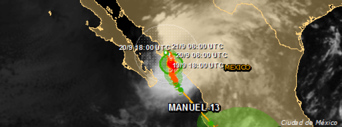
Two tropical storms, Ingrid and Manuel, brought heavy rainfall and caused destruction and chaos throughout Mexico over the last couple of days. Current estimates are that 80 people have been killed. The forecasters are warning of more storms ahead as Manuel re-intensified to hurricane strength in the last few hours and is expected to make landfall again. Tens of thousands of people have been trapped in massive landslides.
Manuel first hit Mexico as tropical storm on Sunday, September 15, and intensified to hurricane strength on Wednesday, calmed down and re-intensified on Thursday.
On Monday, September 16, a major landslide hit small village of La Pintada in the country’s southern mountains. Mexican president Enrique Peña Nieto said that at least 58 people are missing in the village, which has a population of about 400 people. He described the damage there as “catastrophic.” It’s unclear how many people remain buried, he said.
More than half of La Pintada was demolished, few homes were left,” Maria del Carmen Catalan, a 27-year-old mother of three, said at a convention center that serves as a refuge for storm victims (GP).
Looting has broken out in the flooded Mexican beach resort of Acapulco as the government struggled to reach people cut off by flooding.
More than one million people have been affected and Acapulco’s airport terminal was under water, stranding tourists.
Dozens of homes in Tampico, one of the main Gulf ports north of Veracruz, were waterlogged when the Panuco River burst its banks, forcing evacuations.
Just weeks ago a TEPCO official declared a state of emergency at Fukuhima, saying that things could become worse than ever at the plant.
Over the years since the disaster initially occurred there have been mixed signals from the governments of the world and their affiliated scientific organizations. However most independent investigations have shown that things are far more serious than the media has been telling the public.
Additionally, recent radiation readings at and around the site suggest that radiation levels are actually rising.[1] In the midst of this crisis, the Fukushima region is experiencing another natural disaster.
A typhoon just reached the shore near Fukushima this morning, and is predicted to cause deeper complications to the contaminated water in the area.
ABC News reported that “TEPCO workers at the plant are battening down the site as the typhoon approaches. They have attached ropes to outdoor piping and pumps, and are using large weights to try to prevent cranes from possibly toppling over. With torrential rains expected this afternoon, there are fears that more contaminated water will seep into the groundwater and flow into the sea.”[2]
According to The Australian “the typhoon made landfall this morning in Toyohashi, Aichi prefecture, packing gusts of up to 162km/h, the Japan Meteorological Agency said….The typhoon, moving north-northeast at a speed of 45km/h, is expected to head towards the capital and its surrounding region later today, the agency says…. The agency issued the highest alert for “possibly unprecedented heavy rain” in Kyoto and its adjacent prefectures, warning residents in danger zones to evacuate to shelters.”[3]
Throughout the whole entire meltdown process TEPCO and the Japanese government have downplayed the environmental impact of the Fukushima disaster.
One politician was even arrogant enough to drink radioactive water, in a desperate move to save credibility for the government.[4]
All parties involved behind the scenes are remaining completely silent, although the Fukushima Nuclear Accident Independent Investigation Commission (NAIIC) has already concluded that the nuclear disaster at Fukushima was “a profoundly man-made disaster that could and should have been foreseen and prevented.”[5]
In contrast to the official reports coming from the government and the power company, test after test has shown that the meltdown has had a significant impact on the surrounding area.
Sources:
[1] Fukushima Workers Ordered to Cover Detection Devices to Downplay Radiation Levels – Intellihub
[2] Typhoon Man-yi hits Japan raising fears about Fukushima nuclear plant – ABC News
[3] Typhoon stokes fears for Japan’s crippled Fukushima nuclear plant – The Australian
[5] Fukushima was a man made disaster – Pakalert Press
Writer Bio:
JG Vibes is an Intellihub.com investigative journalist, staff writer and editor. He is also the author of “Alchemy of the Modern Renaissance”, an 87 chapter e-book and is an artist with an established record label. Find him on his Facebook.
For media inquires, interviews, questions or suggestions for this author, email: vibes@intellihub.com or telephone: (347) 759-6075.
This article is brought to you byIntellihub.com, A.K.A. the “Civilian Intelligence Agency”.
Please comment, like, share and even re-post this article on your very own blog or website.
Note: Intellihub.com expressively grants permission to repost any article text on this site bearing the name “Intellihub.com” on the article’s byline header, attributing proper link-backs, keeping intact the article’s original byline header and writer bio. Images are subject to copyright by other parties. Intellihub.com maintains a contract with Getty Images.
Flash flooding unleashed by torrential downpours in Colorado has killed at least three people and forced hundreds to flee to higher ground as rising water toppled buildings and stranded motorists in their cars, officials said on Thursday.
Heavy rains drenched Colorado’s biggest urban areas, stretching 130 miles along the eastern slopes of the Rockies from Fort Collins near the Wyoming border south through Boulder, Denver and Colorado Springs.
Among the hardest-hit areas was Boulder County, where the National Weather Service issued a flash-flood warning through 10 p.m. local time. Flood watches were also posted for several counties in central and north-central parts of Colorado.
“There is water everywhere,” said Andrew Barth, the emergency management spokesman in Boulder County. “We’ve had several structural collapses. There’s mud and muck and debris everywhere. Cars are stranded all over the place.”
At least 6 inches of rain has fallen on the city of Boulder and up to 8 inches were measured in the foothills west of town, said Kari Bowen, a Weather Service meteorologist in Boulder, northwest of Denver.
The rains transformed Boulder Creek, which runs through the heart of the city and the University of Colorado’s Boulder campus, into a raging torrent that overran its banks and flooded adjacent parking lots and streets.
Water gushed over sidewalks, roads and bike paths throughout the downtown area as sirens wailed and public-address loudspeakers urged residents to stay clear of high water: “Warning: Flash flood. Please proceed to higher ground. Do not cross standing or running water. Do not cross Boulder Creek.”
The university campus was closed for the day, as were Boulder-area public schools and all municipal office buildings.
More than 400 students were evacuated from ground-floor campus housing overnight, campus police spokesman Ryan Huff said. Roughly 40 buildings on campus were believed to have sustained some flood-related damage, Huff said.
Ron Cobbley, 49, a homeless man who had been camping along the Saint Vrain River west of Boulder near the town of Ward, said he decided to leave the woods and head into town after three days in the rain.
“It was raging with whitewater,” he said of the river.
The old saying applies now more than ever , “don’t be scared, be prepared.” Most people in areas already earthquake prone know to have a plan ready in the case of possible earthquake activity. In already prone areas, now is the time to be aware.
However, several areas around the ring of fire have not experienced large scale movement in a fairly long time. Add in the possibility of movement in Europe, South America, Canada, and along the edge of the North American Craton (plate)… this leads me to urge YOU to develop an earthquake plan, make sure you , your loved ones, family, and even employees / coworkers know it.
Food, water, transportation, communications, shelter, and self defense. Cover the basics, and you’ll be 10 times better off than 99% of those around you.
The fracking story mentioned in the video can be read here: